CeBIT 2010: German police to use open source Navit navigation - Update
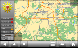
![]() An preview of the Navit interface for German police
An preview of the Navit interface for German police
Source: Navit Project
According to Martin Schaller, the Navit Project Leader, the German district of Brandenburg is trialling the Navit car navigation system for its Police System. Schaller spoke to The H at CeBIT 2010 about the trial. Navit is an open source, cross-platform car navigation suite that includes a built-in routing engine. Schaller says that, while the system is still considered to be in development, the district will be testing Navit this month with at least three of its cars.
Using the system, the central police stations can easily monitor the location of all of the equipped vehicles and determine which is closest to a location for a call. Once a suitable vehicle is selected, the central station can send a message to that vehicle with further instructions and the destination will automatically be sent to the driver. The district of Brandenburg is also reportedly pushing for other police departments in Germany to adopt the system.
Navit features a modular design with a GTK+ and SDL based user interface. The modular design allows the software to use various formats of vector maps and allows a GL accelerated 3D view to be supported. Additionally, Navit can use several sources of map data, including data from OpenStreetMaps and Garmin.
The latest release of Navit is version 0.1.1, which is available to download from the project's SourceForge page. Navit currently speaks 43 languages and can run on a number of platforms, including Linux Windows, Android, the iPhone and the OpenMoko Freerunner. Navit is licensed under version 2 of the GNU General Public License (GPLv2).
Update - Following a readers query The H asked Martin Schaller about the source of the map data for Navit. He says the map data they are using for the Police System comes from the Brandenburg land surveying office. Navit chose this source because, for this application, the data was free and provided the greatest accuracy and detail.
See also:
- CeBIT 2010, a report from The H.
- OpenStreetMap updates its maps of Chile, a report from The H.
(djwm)
![Kernel Log: Coming in 3.10 (Part 3) [--] Infrastructure](/imgs/43/1/0/4/2/6/7/2/comingin310_4_kicker-4977194bfb0de0d7.png)

![Kernel Log: Coming in 3.10 (Part 3) [--] Infrastructure](/imgs/43/1/0/4/2/3/2/3/comingin310_3_kicker-151cd7b9e9660f05.png)